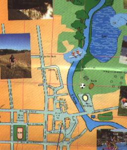
Plaisance ist ein " Bastide " , deshalb viele strassen mit rechte Winkeln.Es gibt zwei Quadrate mit Arkaden ",la Place de l'Eglise "und " la Place de la Mairie "(Das kirchequadrat und das Rathausquadrat).Der fluss Arros fliesst durch Plaisance.Unter Sie konnen die Brucke sehen und links ,das Oval der Arenen.Dann die blaue Fleck der See.Zwischen beide, die Tenisplatze, das "Urlaubdorf"
Das Schwimmbad und die campingplatz sind diese keine blaue und grune Flecke rechts..Plaisance is a "bastide",(village built in the Middle Ages) ,therefore many streets are right-angled with two typical squares with arcades, the Church Square and the Town hall Square which are named after the two last world wars' armistice days. The river Arros flows across Plaisance. On the plan you can see the bridge and on on its left, the oval of the Arenas, then the blue spot of the lake. Between the arenas and the lake, there is the rugby field, the tennis courts and the leisure area where you can rent bungalows.
The swimming-pool and the campsite are represented by this small blue point and this green spot in the bottom right-hand corner.